Save this image free of charge
in 800 pixels for layout use
(right click, Save as...)
|
|
Ref : V01118
Theme :
Cyclones - Hurricanes - Storms - Clouds (438 images)
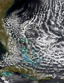
Title : Open-cell cloud formation over the Bahamas
Caption :
What atmospheric scientists refer to as open cell cloud formation is a regular occurrence on the back side of a low pressure system or cyclone in the mid-latitudes. In the northern hemisphere, a low-pressure system will draw in surrounding air and spin it counterclockwise. That means that on the back side of the low pressure center, cold air will be drawn in from the north, and on the front side, warm air will be drawn up from latitudes closer to the equator. This movement of an air mass is called advection, and when cold air advection occurs over warmer waters, open cell cloud formations often result. This image shows open cell cloud formation over the Atlantic Ocean off the southeast coast of the United States on February 19, 2002. This particular formation is the result of a low-pressure system sitting out in the North Atlantic Ocean a few hundred miles east of Massachusetts. (The low can be seen as the comma-shaped figure in the GOES-8 Infrared image from February 19, 2002.) Cold air is being drawn down from the north on the western side of the low and the open cell cumulus clouds begin to form as the cold air passes over the warmer Caribbean waters.
|
|

